If you’re responsible for travel security, then you know that your organization has a duty of care whenever employees depart for their destination.
Most business trips occur without an issue. But there’s always a chance something could go wrong.
In these situations, it’s up to you and your organization to keep staff safe. That applies doubly so if employees travel to unknown locations or dangerous places.
But as COVID and the war in Ukraine have taught us, the situation in an area can change overnight (or at least appear to). New risks can emerge quickly. And conditions in even traditionally safe destinations can deteriorate rapidly.
So how can security teams stay ahead of these challenges to keep employees safe?
Increasingly, organizations have started to invest more resources into open-source intelligence, or OSINT, for travel security.
Fact is, intel gathered through online sources now represents one of the best ways for remote teams to get a sense of what’s happening “on the ground.”
That’s because people continue to post more information on the web, especially through social media. And in many cases, this information can represent more valuable data than official advisories from state governments.
That said, the challenge is collecting and coxing all of this data into something useful.
So in this post, let’s review some OSINT tools for gathering intelligence. We’ll also break down how analysts can create more effective reports and briefings for business travelers.
Learn More: 5 Cognitive Biases That Could Affect Your OSINT Investigations
How Does OSINT Support Travel Security?
Providing pre-trip intelligence on a destination represents an essential part of keeping VIPs and employees safe – yet most organizations fall short in this regard.
Less than half of business travelers receive any pre-trip information from their employers before departure. That results in uninformed staff members left vulnerable to more threats.
Thankfully, OSINT tools allow employees and security teams to understand potential risks ahead of time.
That can put everyone in the position to better address incidents should they occur. Or even better, they can sidestep potential problems entirely.
OSINT tools and techniques allow organizations to spot risks such as:
- Political instability
- Natural and industrial disasters
- Crime and terrorism
- Disease outbreaks
But perhaps more importantly, OSINT supports travel security by ensuring organizations don’t overreact to perceived threats.
Security teams in some organizations may have a reputation for obstructing business. This happens because, all too often, it’s up to this department to wave their fingers at colleagues and explain what they shouldn’t do and why.
But in the case of OSINT for travel security, threat intelligence can turn this narrative on its head.
Deep, on-the-ground insights can allow organizations to confidently carry out operations in situations where they might otherwise halt activities.
And this type of enablement can present an enormous return on investment for businesses.
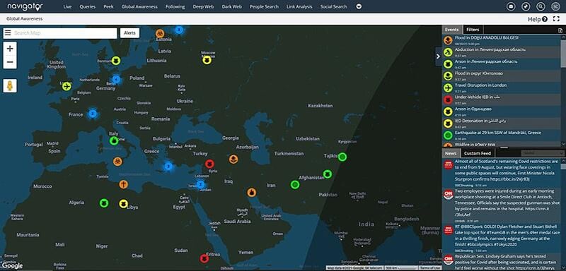
A snapshot of Navigator’s Global Awareness Map, which allows security teams to identify security incidents in a region at a glance.
Take Puerto Rico following Hurricane Maria in 2017, for example.
In the aftermath of the storm, Microsoft executives saw alarming reports about the security situation in the territory. Several agencies posted advisories warning against travel to the area.
Microsoft’s in-house intelligence team, however, provided a more nuanced assessment. They reviewed the situation specific to the company’s footprint and concluded executives would face few security risks in the regions they would visit.
That gave the management team the confidence they needed to continue with their original travel plans.
How to Use OSINT Tools for Travel Security
Using OSINT for travel security generally starts with conducting a threat assessment of the destination. To help get you started, we’ve compiled some of our favorite open-source tools and resources.
To be clear, the sites posted below don’t represent an exhaustive list of services. And certain resources will be more helpful in some regions than others. Still, you can use this list as a guide to get started.
Let’s dive in.
Country Overview
A regional threat assessment requires a basic grasp of national politics, economics, and demographics. It also pays to understand the lay of the land through maps and aerial photography.
The CIA World Factbook
The CIA World Factbook serves as the ultimate reference for world travelers. This site contains detailed information on different topics for every country, such as politics, economics, demographics, geography, energy, and transportation. This serves as a great starting point for further research.
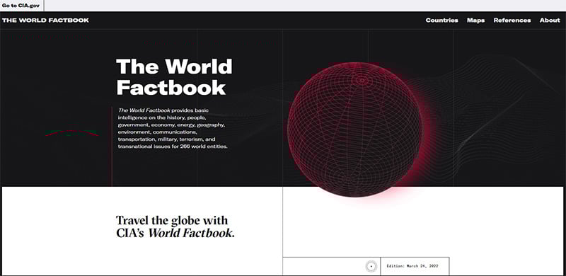 A screenshot of the CIA World Factbook’s homepage. This site serves as a great starting point for any threat assessment.
U.S Department of State
The U.S. State Department provides a safety and security profile for every country worldwide. Each page contains information, such as travel alerts, entry and exit requirements, local laws and customs, health conditions, embassy contact numbers, and other details. All of which can be useful when assessing travel risks in a given area.
Additionally, the agency also assigns a risk rating for each country on a scale between one and four. That said, these ratings can have limited intelligence value. For instance, Canada was assigned a Level 4: Do Not Travel advisory at the time of this writing. This puts the country in the same risk category as Iran, Ukraine, and North Korea. So take these numbers with a grain of salt.
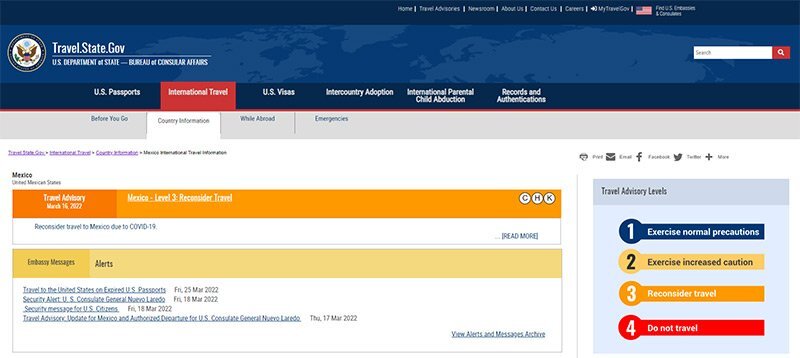 The travel information page for Mexico, provided by the U.S. State Department. Each page contains useful information for travelers, such as advisories, entry and exit requirements, local laws and customs, health conditions, embassy contact numbers, and other details.
Disputed Territories
Every Disputed Territory provides a map of contested regions between countries worldwide. These areas can represent potential hot spots for armed conflicts. And as a general rule, travelers should avoid them when possible.
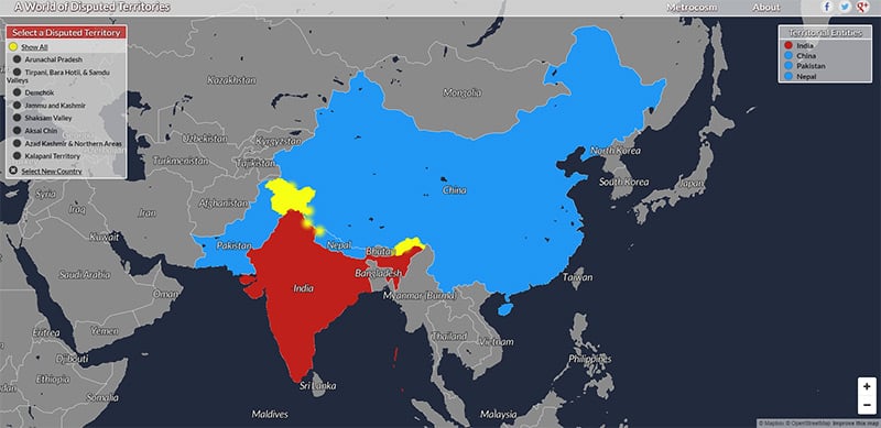 A visual map of contested regions between India and its neighboring countries, provided by Every Disputed Territory. These areas often represent potential hot spots and should be avoided by travelers.
Free Map Tools
Free Map Tools is a nifty add-on to other map services. It hosts a collection of online resources that allow users to measure, search and overlay mark-up elements on maps. Some of the site's popular applications include measuring the distance of a route, calculating the area of an enclosed space, and determining the height of a location above sea level.
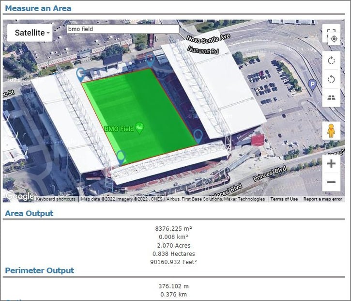 Data plots measuring the area of BMO Field in Toronto, Canada, provided by FreeMapTools.
Local News, Topics, and Trends
Global news outlets, such as CNN or the BBC, represent the obvious place to keep up to date on current events in a region. Hyper-local news, however, typically provides more valuable information for travelers.
Unfortunately, large broadcasters rarely report on community events. So security teams often struggle to obtain detailed, local knowledge from a remote location.
That said, OSINT analysts have many tools and techniques to uncover ‘on-the-ground’ insights. Here are a few of our favorites.
Most cities today have a dedicated Reddit forum, called a subreddit. Admittedly, OSINT analysts should verify any information they find in these groups with other sources. But browsing through historical posts can provide a great insight into the local political, business, and cultural climate.
During emergencies, Reddit users often report breaking news faster than traditional media outlets. Even better, these posts are often accompanied by photos, videos, and other commentaries.
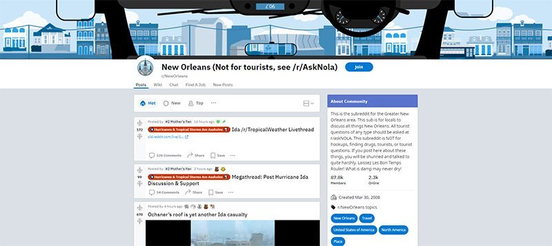 A screenshot of the New Orleans’ subreddit page following Hurricane Ida on August 29, 2021.
Google Trends
Google Trends allows users to see common search queries in a given region. This can uncover facts on the ground that may not be made public through news articles or posts on social media. Analysts can also click on specific keywords and see how the number of search queries for this term has changed over time.
To illustrate the value of this data, consider the COVID Omicron wave in New York City. At the time, health agencies failed to provide an accurate case count due to a testing and reporting backlog. But on December 27, Google queries for terms like “cough,” “fever,” and “Covid symptoms” peaked. This provided OSINT analysts an indication that the spread of COVID throughout the city was well in decline weeks before any confirmation from official data.
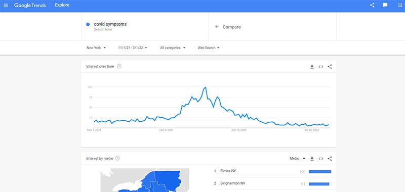 Google queries for the term ‘COVID symptoms’ in New York City peaked weeks before official data sources reported a top in COVID cases.
Snap Map
Snapchat Map allows users to share geolocated content. Start by navigating to a region you want to follow. Color-coded hotspots on the map indicate large amounts of activity. You can then click on highlighted stories to see videos, images, and commentary posted by users.
This tool serves as a way to get a sense of what’s going on in a particular place or learn more about unfolding events. And because it’s hard for users to upload content with fake coordinates, posts on Snap Maps are typically more reliable than other sources.
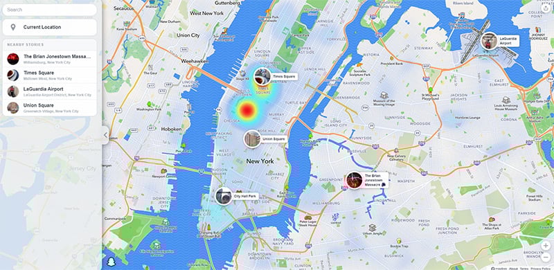 A screenshot of Snapchat activity across New York City. Areas highlighted in red represent places with high levels of social media activity.
Newspaper Map
Newspaper Map is a free online application that plots the location of over 10,000 newspapers worldwide. Use this tool to identify local media outlets in unfamiliar areas.
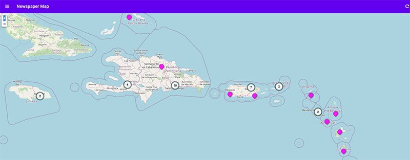 Plots highlighting newspaper publications in the eastern Caribbean, provided by Newspaper Map. This site serves as a great resource for identifying local media outlets in unfamiliar locations.
IBM Watson News Explorer
The IBM Watson News Explorer automatically constructs an information network of breaking stories in real-time. This allows analysts to make sense of a large volume of news results at a glance.
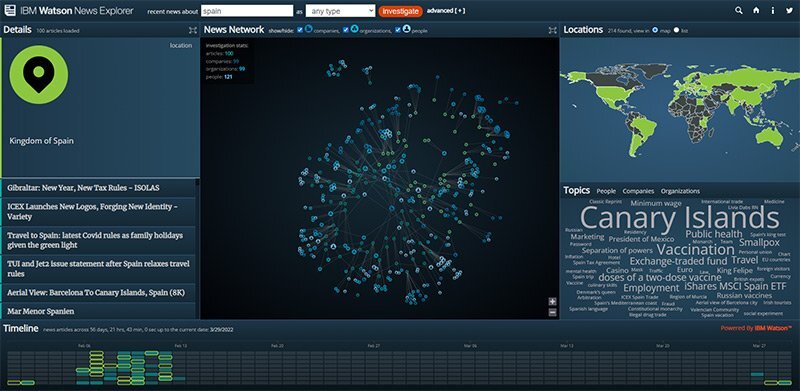 A graphical plot of recent news events across Spain, provided by the IBM Watson News Explorer.
Threats
Every destination has some kind of criminal or terrorist activity. Reviewing up-to-date statistics on these topics represents an essential step for any analyst when conducting a threat assessment.
GeoSure
GeoSure provides safety and security data on popular destinations worldwide. A color-coded safety scale rates locations between 1 and 100. The app even breaks this data down further by different risk factors, such as theft, LGBTQ+ safety, and women’s safety.
GeoSure’s neighborhood-level analysis, however, distinguishes this app from other data sources. Most safety ratings review the security situation across an entire country. But risks to travelers in any nation can vary from city to city, or even from street to street. So GeoSure’s detailed datasets allow intelligence teams to conduct far more effective analysis.
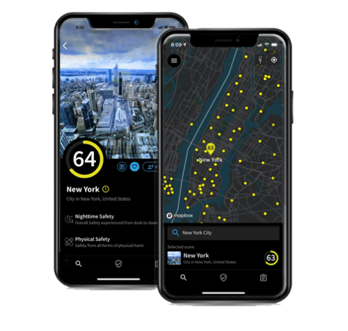 A screenshot of the GeoSure travel safety app.
Global Terrorism Database
The Global Terrorism Database (GTD) provides a detailed breakdown of every unclassified terrorist attack worldwide. For each incident, the GTD provides the date and location of the attack, the type of weapons used, the nature of the target, the number of casualties, and the group or person responsible. This tool represents an essential resource for assessing the risk of attacks in a given area.
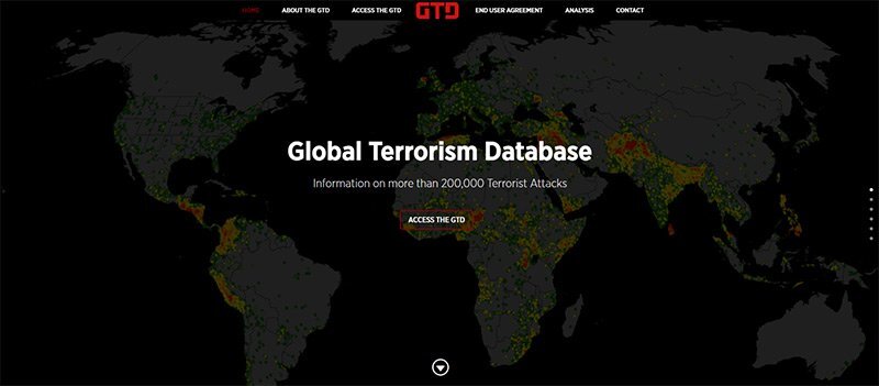 A screenshot of the Global Terrorism Database, which represents a useful resource for assessing the risk of terrorist incidents.
Numbeo
Numbeo is a crowd-sourced database that rates locations based on many factors, such as job opportunities and cost of living. The site’s crime section reviews how residents perceive the risk of theft, violence, and corruption in their city. Note that because these statistics only come from informal surveys, you should verify this information with other sources.
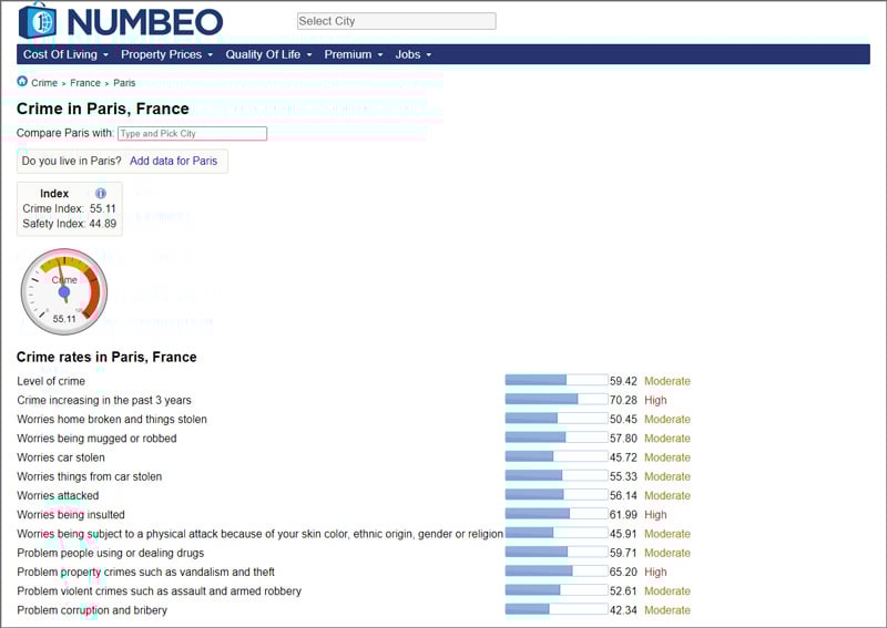 An overview of the crime rates in Paris, France, provided by Numbeo.
Health Risks
Following the COVID-19 pandemic, health risks have become a focus for corporate security teams. That applies doubly so for organizations with many employees on the road.
HealthMap
HealthMap collects raw data from different agencies to provide a comprehensive view of health risks worldwide. This can serve as an early alert system for disease outbreaks before they get reported by traditional news outlets.
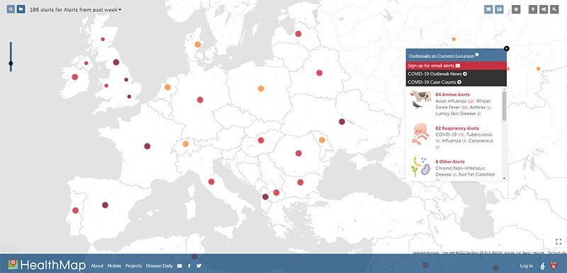 An overview of disease outbreaks across Europe, provided by HealthMap.
Johns Hopkins COVID Dashboard
If you’re looking to track COVID, then you will want to bookmark the Johns Hopkins COVID Dashboard. This application provides real-time information on the state of the pandemic worldwide. Users can also select specific countries or regions and track how the disease has spread there.
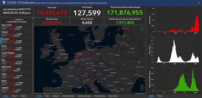 An overview of the spread of COVID-19 across Europe, provided by the Johns Hopkins COVID Dashboard.
Situational Awareness
Security teams need to keep tabs on many events and risks that could adversely affect employees. Beyond broadly following news and social media, here are a few specific tactics and resources to ensure ongoing situational awareness.
EMS Services
Many local emergency services, such as fire departments and police precincts, have accounts on social media. Before an employee leaves for their trip, follow these pages or feeds. EMS services often report local events hours before stories reach mainstream news outlets.
 A snapshot of the New York Police Department’s Facebook page.
FlightRadar24
Flightradar24 provides real-time flight data on thousands of aircraft worldwide. Useful for monitoring VIP travel plans or the impact of weather events on global transportation.
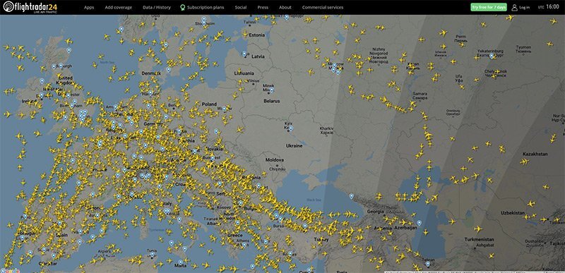 A snapshot of flight traffic over Europe, provided by Flightradar24.
Live UA Map
Live UA Map provides a great snapshot of what’s happening on the ground in a given region. The site curates important events and plots them on a simple map interface. Users can also go back and review incidents that happened days or weeks ago.
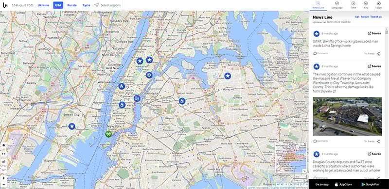 A plot of recent security incidents across New York City, provided by Live UA Map.
Tips for Delivering More Effective Threat Intelligence
OSINT can serve as a powerful tool for keeping employees safe on the road. That said, it’s important to keep in mind that business travelers do not represent traditional consumers of intelligence.
The most thorough threat assessment in the world is worthless if your customer doesn’t actually follow your advice. Or even worse, if they don’t read your briefing altogether.
So to improve the chances clients will consider your perspective, here are a few suggestions for preparing an effective briefing or report.
- Explain the value of this intelligence. Audiences in the private sector have likely received business, competitor, or consumer intelligence. They may not, however, be familiar with threat intelligence. For this reason, it makes sense to take the time, either through a formal presentation or informal one-on-one chat, to explain the value of your briefings and how they should be interpreted. That represents an essential step in organizations that have never had an intelligence function before.
- Be careful with military or intelligence terminology. Most OSINT analysts have some background in the military or public sector. But keep in mind that the words or terms borrowed from these organizations can intimidate private sector audiences. Where possible, try to mimic the language used by peers in your organization.
- Provide actionable advice. Before publishing a report, check with yourself, “What am I asking people to do?” It’s not enough to provide an overview of a new threat. For readers to find value in your services, you need to explain what actions they should take. Always provide a call to action somewhere in your briefing.
- Consider company culture. Intelligence teams can sometimes feel like outsiders in their own company. But this can put a barrier between you and the people meant to use your reports and briefings. To avoid this problem, try to mimic the culture of your organization. In the context of a threat intelligence report, this might mean using the same fonts, templates, and terminology as other departments in the company.
- Deliver intel in a format your audience prefers. Does your audience prefer short, two-page briefings? Or maybe they prefer podcasts and videos? Don’t limit the format of your report to what you have always done. Ask your target customer or audience how they like to receive information. Then do your best to adhere to their guidelines. That makes it much more likely they will read the information you have to provide and follow your advice.
- Ask for feedback. You likely can't talk to everyone that uses your intelligence. That said, it’s worth taking the time to chat with a handful of key decision-makers. What parts of your report did they find most useful? Did they read your report at all? Their feedback will often reveal surprising insights for you and your team.
The Bottom Line on OSINT for Travel Security
Every company that sends an employee on a trip for business has a duty of care — their moral and legal obligation to ensure their safety.
The COVID-19 pandemic and the invasion of Ukraine suggest this will become a tougher challenge in the years to come. Travelers and security teams will need online data to make better-informed decisions to address new threats.
For this reason, OSINT will likely represent a larger and larger piece of every company’s travel security plan.